Whether you’re embarking on a single-day hike or a multi-day adventure, hiking in Alpstein is unique and breathtaking.
In this post, we’ll guide you through a three-day hiking journey in the Alpstein, weaving through both well-known spots and hidden paths.
Many travellers and day visitors visit the Alpstein for a day, typically focusing on iconic locations like Ebenalp with the Berggasthause Äscher and the amazing Seealpsee.
However, Alpstein offers so much more. Once the day-trippers leave and tranquility sets in, the entire area becomes even more enchanting. Witnessing the sunset from your mountain hut terrace creates memories that linger long after your departure.

List of Contents
- 1 Where is Alpstein, and How to get There?
- 2 Hotels and Accommodation near by
- 3 Preparation for Hiking in Alpstein
- 4 Three-Day Hike in Alpstein – Appenzell
- 5 Overview of the Alpstein Golden Route
- 6 Detailed Description of Hiking in Alpstein
- 7 First Day – Hiking in Alpstein
- 8 Second Day – Hiking in Alpstein
- 9 Third Day – Hiking in Alpstein
- 10 Hiking Map – Multiday Hiking in Alpstein
- 11 Alternative Routes in Alpstein
- 12 Our Thoughts on Hiking in Alpstein
Where is Alpstein, and How to get There?
The Alpstein Massive, also known as the Northern Alps, is located in Appenzell in northeastern Switzerland. Various entry points make this small mountain range a popular choice.
The main entrance to Alpstein is Brüllisau – Wasserauen, but you can also reach it from the St. Gallen side through Staubern and over Säntis.
Getting There by Train
Like many places in Switzerland, traveling by train is optimal. This allows flexibility in entering and exiting Alpstein from different locations.
Parking can be challenging to find, making the train to Wasserauen in Appenzell a preferable option. From there, you can easily reach the Ebenalp cable car or explore the numerous hiking trails on foot. This is also the fastest route to Seealpsee.
Getting There by Car
Wasserauen now has a sizable paid parking lot. However, it fills up quickly, especially on weekends and during favorable paragliding conditions. If full, try Brülisau near the cable car to Hohenkasten.
Hotels and Accommodation near by
Appenzell is a beautiful Swiss village and maybe a great place to spend the day before your multiday hike in the Alpstein or the day after.
If you follow our exact itinerary you may want to change the map to Frümsen , Grabs or anything on the other side of the Alpstein. As this is the entry and exit point of this amazing hike.
Preparation for Hiking in Alpstein
Changing your hiking route on short notice is easy in Alpstein due to the close proximity of many mountain huts (Bergrestautants). It’s an ideal place for families to embark on their first multi-day hike and experience a night in a mountain hut.
During the peak season, it’s highly recommended to reserve mountain hut accommodations when hiking in Alpstein.
Best Time to Hike in Alpstein
For us, the best time to hike in Alpstein is undoubtedly autumn, preferably outside school holidays.
In spring, it’s essential to check the snow conditions. Despite its relatively low altitude, Alpstein accumulates a significant amount of snow each year. Some exposed sections can be risky in icy conditions. It’s crucial to understand that hiking in Alpstein involves navigating white-red-white alpine trails, not leisurely Sunday strolls. Every year, there are fatal accidents involving ill-prepared individuals lacking the proper equipment. Proper hiking boots are essential.
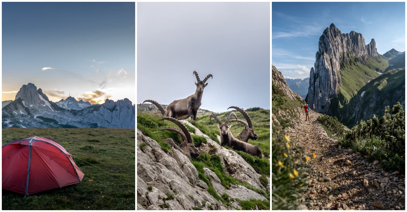
Wild Camping in Alpstein
While rumors vary, wild camping in Alpstein is generally not permitted. Some claim it’s allowed if you’re bivouacking above the tree line or if you seek permission from landowners. However, finding the right person to ask isn’t always straightforward. During our multi-day hike in 2021, we inquired at the Roslenalphütte whether we could pitch our tent on Mutschensattel.
Drone Use in Alpstein
In general, flying drones in Alpstein is prohibited, especially around Ebenalp, Aescher ( Äscher), and Seealpsee, as well near other mountain huts. While you might fly your drone if you’re far away from everything, it’s essential to note that I am not the law. All our drone footage was captured before the ban came into effect.

Three-Day Hike in Alpstein – Appenzell
For our first multi-day hike in Alpstein, we selected part of the renowned Königstour and combined it with other trails. Although our Alpstein tour could be condensed into two days, we prefer a slower pace to truly savor nature and surroundings.
Summary of Our Hike:
- Total Distance: 30 km
- Positive Elevation in Alpstein: 2401 meters
- Negative Elevation in Alpstein: 2408 meters
- Highest Point: Säntis Mountain, 2499m
- Start & End Point: Staubern Kanzel
- Overnight Stops:
- One night in a tent on Mutschensattel
- Second night at Berggasthaus Mesmer
(our third choice due to Säntis closure and no availability at Berggasthaus Meglisapl. Considering the adverse weather forecast, we opted against camping and were glad for the downhill hike to Mesmer, given the challenging winds in Alpstein.)
Overview of the Alpstein Golden Route
First Day:
– Starting Point: Frümsen
– Ascend with Staubernbahn to Staubern Kanzel
– Hike to Mutschensattel
– Distance: 5.5 km
– Elevation Gain: 350 meters
Second Day:
– From Mutschenpass via Zwinglihütte to Altmann Pass
– Descend to Rote Pass Hut (only for experienced hikers)
– Continue over the exposed but federally insured Lisengrat to Säntis
– No overnight stay at the originally planned location; Tuesday is a closing day
– Found accommodation at Mesmer Berggasthaus due to adverse weather
– Distance: 10.5 km
– Elevation Gain: Ascent 725m / Descent 1204m
Third Day:
– Descend from Mesmer to Seealpsee
– Hike via Bogenartlücke to Fählensee
– Return to Staubern
– Distance: 13.1 km
– Elevation Gain: Ascent 958m / Descent 1088m

Detailed Description of Hiking in Alpstein
First Day – Hiking in Alpstein
In the afternoon, we take the Staubernbahn from Frümsen to the panoramic Staubern Kanzel. Accessible by Postbus from Grabs, this self-service cable car operates until approximately 22:00. We choose this route to explore lesser-visited paths in Alpstein, with the added bonus of spectacular views from the mountaintop restaurant.
The hike kicks off towards the photogenic Saxer Lücke. Initially, the trail along the rock wall is exposed, but safety measures are in place. As the path becomes less exposed, we relish the panoramic views of Säntis and Fählensee, leading to the awe-inspiring Saxer Lücke.


Kreuzberge & Mutschensattel
Ascending the steep path to the Mutschensattel Plateau, we pass the jagged Kreuzberge and cross alpine meadows where tame sheep graze. Our eyes often shift to the Kreuzberge, where we witness mountaineers practicing acrobatics on a trapeze rope between two peaks – a truly awe-inspiring sight. Before reaching the Mutschensattel Plateau, we navigate a snow cover (in summer).


Scenic Sunset at Mutschensattel Plateau
The plateau offers ample space, providing a stunning view. As the sun sets, casting a warm glow over the landscape, we bask in the beauty of the Churfirsten on one side and the recognizable sights of the Säntis on the other. This serene moment marks the end of our first day while hiking in Alpstein.


Second Day – Hiking in Alpstein
After a restful night but an early wake-up call (courtesy of the cows), we set out towards the Zwinglipasshütte SAC.
At this altitude, one feels completely alone in the world, surrounded by an incredible calmness and tranquility.
Zwinglipasshütte for Supplies & Water
For those who prefer not to sleep in a tent, we highly recommend spending the first night at the Zwinglipasshütte SACat an altitude of just 1999m. From the Mutschensattel Plateau, it’s about a 3 km hike to the hut.
The Zwinglipasshütte is also excellent for those running low on provisions. Here, you can replenish supplies and, most importantly, refill your water bottles.


Ascent to Alltmannpass and Rotsteinpass
The path leading up to the base of the Altmann is steep. Zigzagging slowly up the mountain, we pause frequently to catch our breath and enjoy the breathtaking views behind us.
And then, a massive herd of ibex crosses our path. Some of these majestic creatures lounge on the hiking trail, seemingly unperturbed by our presence, while others curiously observe us. It’s a truly enchanting encounter.


Altmann’s Path to Rotsteinpass
I highly recommend the next section of our hike only for those who are sure-footed and free from a fear of heights. I would take extra precautions with children from this point, perhaps using a harness or rope.
Initially, the path isn’t apparent. It descends steeply into the valley, with a narrow and rocky ridge. Once we spotted the narrow mountain path, we carefully made our way.
This is a section where you absolutely cannot slip or stumble, as the drop is significant. Despite having wire ropes for support, extreme caution is essential.
Our gaze often drifts up towards Säntis, as it’s where we intended to spend our second night. We manage the descent without significant difficulty, even with the steep trail.
Standing at the edge, the Rotsteinpass Gasthaus is visible below. Here, we treat ourselves to a hot chocolate before conquering the well-known and highly exposed Liesegrat.


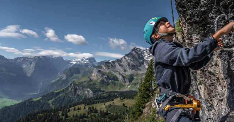
The Path over Liesegrat & to Säntis
Refreshed and strengthened, we begin the ascent to the Liesegrat—a spectacular route with its own challenges. The trail has literally been carved into the rocks and secured with ropes, with a significant drop on at least one side. So, caution is essential here!
The effort to create such access is truly commendable. Many hikers traverse the Liesegrat from Säntis to the Rotsteinpass Hut and back, drawn to its spectacular nature.

Ascent to Säntis
After conquering the Liesegrat, we face another ascent, climbing to the summit of Säntis. Our legs are already feeling the strain, and in our thoughts, the anticipation of reaching today’s destination is persistent—just a bit more uphill and we’ll be checking in.
However, fate had different plans.
Surprisingly, Säntis’ pension is closed on Tuesdays. So, if you plan to stay at Säntis, make sure to check for their day off.
Unfortunately, the weather forecast predicted a stormy night, leading us to decide against camping. We had to find an alternative. Fortunately, Alpstein has many mountain huts where you should typically find a mattress available.
The Mesmer Berggasthaus had space for us.


Mesmer Berggasthaus in Alpstein
The descent from Säntis is long, steep, and seemingly endless. Mesmer is visible from afar, but the path feels interminable. After all the elevation we’ve covered in Alpstein today, our knees protest during the descent.
Especially considering the limited time, we couldn’t fully enjoy Säntis. If you plan to stay there, organize your hike to have sufficient time or move at a faster pace to avoid running out of time.
Nonetheless, we eventually stood in front of the mountain hut with backpacks, sore knees, and a tired body.
We had a multi-bed room to ourselves, a luxury we appreciated. However, on that night, twenty people could have snored beside me, and I probably wouldn’t have noticed.
A fierce thunderstorm passed over Alpstein overnight, but thankfully, we were not in our tent.
Third Day – Hiking in Alpstein
After a good breakfast and a restful night, we continued on the third day, initially descending to Seealpsee.
By the way, we find the Mesmer ideal for families looking to try out hiking to a mountain hut and staying overnight. It’s not far from Wasserauen via Seealpsee.


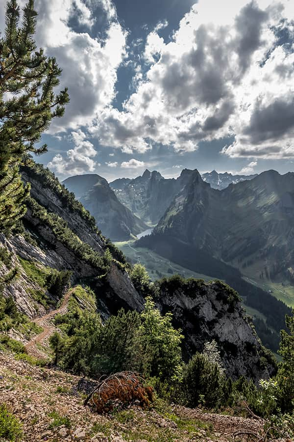
Over the Bogenartlücke to Fählensee
A few more meters in elevation and high points await us today. First up is Seealpsee, a beautiful mountain lake ideal for a picnic. Popular among families and friends, Seealpsee is easily accessible from Wasserauen. Read how to get to Seelapsee on our blog.
For us, the journey continues to the next lake, Fählensee at Bolenwees. On the map, the route seemed relatively moderate, but we were in for a surprise. The climb to the Bogenartlücke was steep, and we mistakenly assumed that Fählensee lay just on the other side. Wrong again. After ascending to the Bogenartlücke, we had to navigate a steep descent on the other side.
Welcome to Alpstein—where it’s always up and down.
Our destination seemed within reach, yet it appeared to elude us the closer we got. Another uphill stretch awaited us before reaching Fählensee, but not for much longer. The joy was immense when we finally glimpsed the emerald-green water. Quickly, we slipped off our hiking boots to dip our feet into the ice-cold but refreshing mountain lake.


Back to Staubern Kanzel
Fählensee lies on a straight line with Saxer Lücke, albeit 465 meters lower. The option was to return to Staubern via Saxer Lücke, but truth be told, we weren’t eager to conquer 465 more meters in elevation. Consulting the Alpstein hiking map, we found an alternative route directly to Staubern, roughly the same distance but with a slightly less steep ascent. A prudent choice for our tired legs.
We followed the broad trail, passed through several cow pastures, and admired picturesque Alpine barns before the ascent began. A final effort, and we made it, even enduring the last few kilometers in the rain.
Now, all that remained was to descend with the Staubernbahn and savor an ice cream somewhere.


Hiking Map – Multiday Hiking in Alpstein
Here is our Alpstein Golden Tour. Click on the map to get full access.

Alternative Routes in Alpstein
For those with more time or a desire for extra kilometers, an alternative route exists.
- From Säntis, instead of descending to Mesmer, traverse the Rosegg (often over snowfields in early summer) to Öhrligrueb and onwards over Lötziälplisattel to Schäfler. Consider staying overnight here to witness the sunset spectacle.
Continue the journey over Ebenalp and Gasthaus Äscher to Seealpsee. The final leg would then align with our route: over the Bogenartlücke to Fählensee and onwards to Staubern
- For travelers using public transportation, skipping Frümsen (where our car is parked), head directly from Seealpsee to the Wasserauen train station. Alternatively, incorporate Fählensee into the hike and proceed from there to Brülisau, passing by Sämptisersee.
Our Thoughts on Hiking in Alpstein
As you may have noticed, we adore Alpstein and wholeheartedly recommend it. Whether for a day trip or a multi-day hike, Alpstein remains something special. And, as always, leave only your footprints. In recent years, Alpstein has gained popularity through social media, attracting more and more hikers. Let’s hope it stays as beautiful as it is.
Other Alpstein Blog posts
I hope that the information provided here when you are planning a Multi day Hiking trip in the Alpstein will prove itself useful.
If I have left anything out, please ask your questions in the comments below and share your experience, so that other readers can join in the conversation and benefit from your queries and stories as well


6 thoughts on “Multi-day Hiking in Alpstein – The Alpstein Royal Hiking Trail”
Thanks for the hiking ideas and the detailed descriptions. I wonder if I could find something similar for the region around Adelboden. Maybe with some advice of nice accommodations such as a Parkhotel or a Wellness Spa Hotel.
Hi: Well you already mentioned two hotels. We would love totes these one day. Enjoy your hike!
Hello – thanks for your amazing blog! May I ask please when exactly did you go on this hike? we want to go in October but thinking it might be too snowy!
Thanks
Hi, I think you should be ok in October regarding snow level. This area in Switzerland is not that high and snow only settles in December. We did it late summer.
have a nice trip Regards Corina
“In general, flying drones in Alpstein is prohibited” is a false statement. Flying drones is forbidden in the entire Alpstein massif.
Hi David
Thanks for clarifying