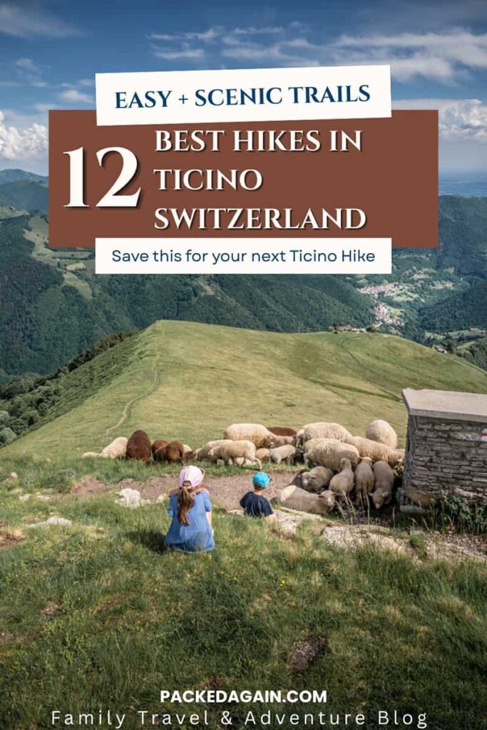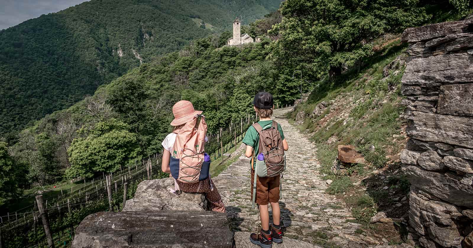
Ticino is one of the most rewarding regions in Switzerland for hiking.
From easy lakeside walks to panoramic mountain trails and hidden valleys, there’s something here for every level. Whether you’re travelling as a family or looking for scenic viewpoints without long climbs, Ticino offers incredible variety.
In this guide, we’re sharing some of our favourite hikes in Ticino — from relaxed strolls to more adventurous trails across the region.
If you’re planning a full trip, you can also explore our guide to the best places to visit in Ticino.

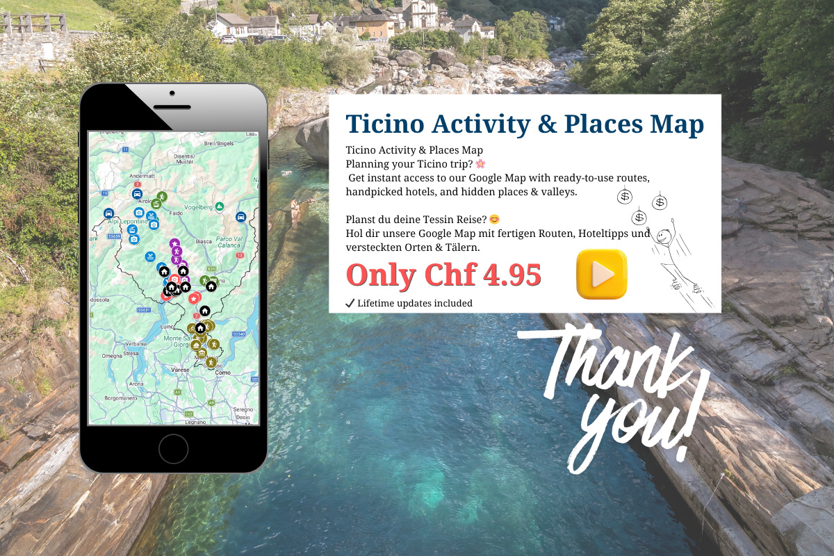
Plan Your Hikes with Our Ticino Map
If you’re planning to explore several of these hikes, it really helps to see everything in one place.
We’ve created our Ticino Map, where we’ve marked all the hikes in this guide — plus additional viewpoints, hidden spots and places to stay.
It’s the exact map we use ourselves when planning our trips.
Best Hikes in Ticino at a Glance
- Parco San Grato to Morcote
- Monte Generoso viewpoints
- Agno to Caslano lakeside trail
- Olive Grove Path to Gandria
- BoBosco Trail (Verzasca Valley)
- Corippo hike (Verzasca Valley)
- Hike to Cascata del Salto (Vallemaggia)
- Foroglio Waterfall & Val Calnègia
- Carasc Tibetan Bridge
- Bellinzona Castles loop
- La Via del Ceneri
- Val Piora & Lago Ritòm
Need Help Planning Your Switzerland Itinerary?
Plan your dream Switzerland trip with local insider knowledge, hidden gems and the best scenic routes — without wasting hours researching.
- Personalised itinerary
- Hidden gems & scenic routes
- Family-friendly recommendations
Easy & Family-Friendly Hikes in Ticino
1. Parco San Grato to Morcote
This is one of our absolute favourite hikes in Ticino.
Start in Lugano and take the bus to Carona Paese, a beautiful village above the lake. From here, the trail leads through Parco San Grato, known for its colourful gardens and open viewpoints.
There’s also a playground and even a barefoot path, making this a great option for families.
As you continue through the forest, the path opens up to stunning views over Lake Lugano before descending towards Morcote.
You can also find this route in our Lugano itinerary.
- Distance: 5.7 km / Ascent 185 metres / Descent 497 metres
- Start: Lugano / Finish: Morcote
- Transport: Bus + boat
Get the full hiking description from Parco San Grato to Morcote Hike on our blog

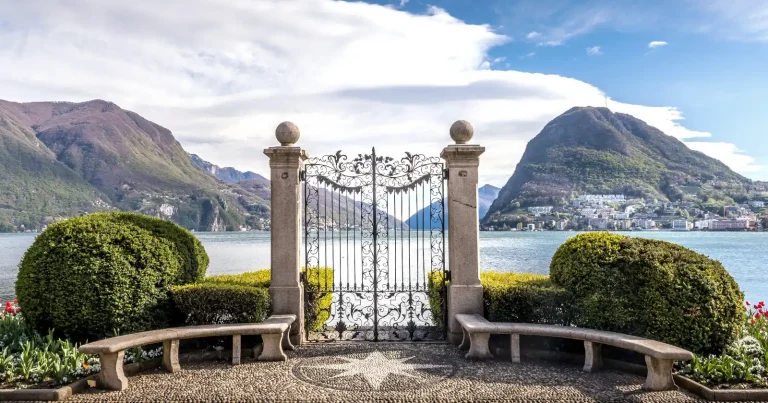
2. Agno to Caslano (Easy Lakeside Trail)
This is one of the easiest hikes in Ticino — perfect for families or a relaxed day by the lake.
Starting from Agno, the path follows the shoreline all the way to Caslano, passing small harbours and quiet swimming spots.
We actually biked this route, but it works just as well as a walk.
If you’re up for more, you can add a short climb up Monte Caslano for a beautiful viewpoint. We also included this route in our things to do in Ticino guide as one of the easiest lakeside experiences.
Hiking Facts
- Distance: 5.1 km
- Transport: Train
Good to know
If you’re up for more, you can add a short climb up Monte Caslano for a beautiful viewpoint.

3. Hiking the Olive Grove Path to Gandria
This is probably more of a scenic stroll than a proper hike — but still one of the most beautiful walks along Lake Lugano.
We especially love this one in the evening, when the golden light reflects on the water and everything feels a bit slower and quieter.
The path follows the shoreline and leads you past some of the oldest olive trees in Ticino, always accompanied by the gentle sound of the waves along the lake.
At the end, you reach Gandria, a small village full of character with its narrow streets and traditional feel. This is one of our favourite easy walks in the Lugano region and also featured in our Lugano itinerary.
Hiking Facts
- Distance: 2.4 km
- Ascent / Descent: 38 m / 34 m
- Start: Castagnola (Lugano)
- Finish: Gandria
- Transport: Optional boat
Good to Know
If you’re visiting in the evening, a great option is to take the boat from Lugano to Gandria, enjoy a relaxed meal, and then walk back along the lake.

Scenic Viewpoint Hikes in Ticino
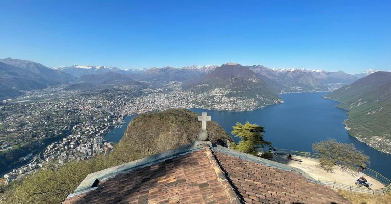
4. Monte Generoso – Valle di Muggio
Another classic hike in Ticino that should not be missed.
Hiking at Monte Generoso (1704m) offers a completely different perspective of the region. Whether you choose a longer hike across the mountain or simply head to the viewpoints, this area gives you plenty of flexibility.
What we love most about this hike is how it takes you deep into the Valle di Muggio, where endless shades of green dominate the landscape and the atmosphere feels quiet and untouched.
And if you’re someone who loves big views, this is one of those places you simply shouldn’t skip.
From the top, you can marvel across the entire Ticino region, with views stretching far into the Valais Alps and even down into Italy. It is no question that this places needed to be in our guide to the best places to visit in Ticino.
How to Get There
To reach Monte Generoso, take the cogwheel train from Capolago (near Melide).
Alternatively, you can hike up to the summit.
The train stops at several points along the way, giving you the option to get off and hike sections of the trail — a great way to combine both experiences.
Hiking Facts
There are multiple hiking routes and variations around the summit area, depending on how much time and effort you want to put in.
- Start / Finish: Monte Generoso summit area
- Transport: Cogwheel train from Capolago
Good to Know
At the top, you’ll find the impressive Fiore di Pietra, designed by Swiss architect Mario Botta.
There is both a self-service and an à la carte restaurant — perfect for enjoying the views a little longer.
This is also one of the viewpoints featured in our guide to easy-to-reach viewpoints in Switzerland

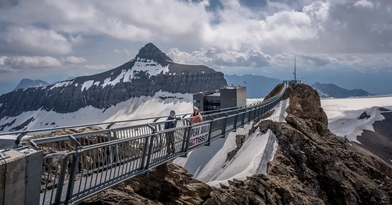
5. Carasc Tibetan Bridge
This is one of the most unique hikes in Ticino.
The highlight is crossing the Tibetan bridge, suspended high above the valley. It’s a great experience, but it does require a bit of planning.
If you take the cable car, make sure to book in advance, especially in peak season.
Hiking Facts
- Distance: 5.5 km / Ascent 264 metres / Descent 640 metres
- Start / Finish: Monte Carasso cablecar station / Sementina – Monte Carasso
- Finish: Sementina – Monte Carasso
Good to know
There are different options on how best to hike the Tibetan Bridge in Ticino.
Most important is that if you take the cablecar up to the hamlet of Curzútt you must prebook your time slot. (Especially during peak season).
Read our full guide to help you plan the Carasc Tibetan Bridge hike

6. Hiking around the Bellinzona Castles
At first, this might sound more like sightseeing than hiking — but once you start walking between the castles, you’ll quickly realise how much ground you actually cover.
The three castles — Castelgrande, Montebello and Sasso Corbaro — are all part of a UNESCO World Heritage Site, and each one offers something different.
Our personal favourite was Montebello, the middle castle.
Walking between them feels like stepping back into medieval times. The walls, towers and surrounding landscape give this hike a completely different atmosphere compared to the rest of Ticino.
If you have the time, we highly recommend doing the full loop starting and ending in Bellinzona old town.
If you prefer an easier option, take bus line 4 up to Sasso Corbaro and start from there.
Hiking Facts
- Distance: 5.5 km
- Ascent / Descent: 280 m
- Start / Finish: Bellinzona Old Town
- Transport: Optional shuttle bus
Good to Know
This route also works well by bike — which is how we explored it.
If you plan to visit inside the castles, you’ll need a Bellinzona ticket, which is definitely worth it.
At the time of our visit, there was a Michelangelo 3D exhibition, which made the experience even more memorable.

Hidden Gems & Valley Hikes
7. BoBosco Trail – Verzasca Valley
If you’re travelling with kids, this is a must.
The BoBosco trail turns hiking into a game, with interactive stations where a wooden ball rolls, jumps and travels along the route.
Meanwhile, you get to enjoy the stunning Verzasca Valley and its crystal-clear river.
Hiking Facts
- Distance: 5.5 km / Ascent 45 metres / Descent 237 metres
- Start: Brione / Finish: Lavertezzo Valle Verzasca
- Transports: Bus
Good to know
There are two BoBosco trails which means twice as much fun along the Verzasca Valley!
This trail is between Gerra Verzasca and Sonogno. The trail is more in the open and has less shady sections, so keep this is mind should you visit Verzasca on a hot summer day.
Read our full guide to the BoBosco Trail. And check out our BoBosco hiking Video

8. A Hike to Corippo – Valle Verzasca
If you have time, you could easily spend a full day hiking in the Verzasca Valley — it’s one of the most beautiful areas in Ticino.
This hike starts in Lavertezzo, right at the famous Ponte dei Salti, the iconic stone bridge.
Before heading off, it’s worth spending some time here. On warm days, people gather around the river, jumping into the crystal-clear water or relaxing on the large rocks. It can get busy — but it’s part of the atmosphere.
From here, the trail follows the valley down towards Corippo, one of the smallest villages in Switzerland.
What makes Corippo unique is that it has been transformed into an Albergo Diffuso — a hotel spread across the village, with rooms located in different houses and a central reception and restaurant.
It’s a beautiful concept and has brought new life back into this historic place.
Hiking Facts
- Distance: 3.2 km / Ascent 86 metres / Descent 68 metres
- Start / Finish: Lavertezzo / Corippo
- Transport: Bus
Good to know
You could also hike all the way to Verzasca Dam and catch the bus there. This would be a 11.5 km hike along the Verzasca Valley.

9. Hike to Cascata del Salto – Vallemaggia
This is one of the most accessible and rewarding short hikes in Ticino — especially on a warm day.
Located in the village of Maggia in the Vallemaggia, Cascata del Salto is a powerful waterfall where three cascades merge into one dramatic drop, creating a deep natural pool below.
While it’s a popular swimming spot in summer, it’s just as worth visiting as a short hike.
The Hike
From Maggia Centro, follow the brown signs marked “Cascata del Salto”. The trail leads you out of the village and into the forest, gradually guiding you towards the river.
After around 20 minutes, you’ll reach the waterfall.
Along the way, you’ll pass smaller pools and quiet river sections where families often stop. If you continue along the main path, you’ll reach the base of the main falls.
Optional Loop Hike
If you’d like to turn this into a slightly longer and more scenic hike, follow the “Giro della Valle del Salto” trail.
Instead of heading directly to the waterfall, take the route towards Capela da La Pioda.
We recommend doing this loop anticlockwise:
- hike up on the right-hand side of the river
- return on the left-hand side
This adds a bit more variety and gives you different views along the valley before reaching the waterfall.
Definitely one of the easiest hikes in Ticino if you’re looking for a short walk with a big reward.
Hiking Facts
- Distance: ~2–3 km (depending on route)
- Time: 20–45 minutes
- Start: Maggia Centro
- Transport: Bus (Line 315 from Locarno) or car
Good to Know
This is a popular spot during summer, especially on hot days.
The area directly around the waterfall has limited space, but if you walk a bit further along the river, you’ll find quieter spots to sit and relax.
If you like to know some more swimming spots along the Vallemaggia, read our blog post where you find several epic swimming spots.


10. Hike the Foroglio Waterfall & Val Calnègia (Vallemaggia)
This is easily one of the most beautiful hikes in Ticino — and in our opinion, it belongs on any best autumn hikes in Switzerland list.
While it’s stunning throughout the year, it truly comes alive in autumn, when the Val Calnègia valley turns into a palette of deep reds, golden yellows and rich browns.
Start your hike in the small village of Foroglio, deep in the Vallemaggia. Before heading up, take some time to explore the village itself. With its traditional stone houses and slate roofs, it almost feels like stepping into a different time — or even a scene from a Hobbit movie.
One thing we found fascinating is that many of the houses here are closed during winter, as residents move further down the valley.
From the village, walk to the foot of the Foroglio waterfall, one of the most photogenic waterfalls in Ticino.
To reach Val Calnègia and the Puntid area, you’ll need to hike up a steep path starting just behind the village. The trail climbs alongside the waterfall through the forest.
There are quite a few steps, and some can be slippery, but overall it’s manageable and well worth the effort.
And then you reach the top.
The landscape opens up into a quiet alpine valley dotted with old stone shelters — and especially in autumn, the colours here are simply breathtaking.
Hiking Facts
- Distance: 1 km
- Ascent / Descent: 197 m
- Start/ Finish: Foroglio Village / Puntid Bridge (Val Calnègia)
- Transport: Bus or car
Good to Know
If you’re visiting in autumn, keep in mind that the valley gets very limited sunlight.
When we visited in October, the sun only reached the valley between 11:30 and 14:00 — something worth planning your visit around.

11. La Via del Ceneri – Historic Trail
This historic trail connects the regions of Ticino and follows an old trading route.
It’s an easy and educational hike, perfect for families.
Hiking Facts
- Distance: 6.9 km / Ascent 73 metres / Descent 424 metres
- Start / Finish : Piazza Ticino – on the Monte Ceneri Pass / Cadenazzo
- Transport: By train and bus
You can also read more about the historic Via del Ceneri Hike on our blog

Images along the Via Del Ceneri – Hiking Ticino
12. Val Piora & Lago Ritòm
This is one of the most unique landscapes in Ticino. And not very often visited by tourists.
You reach the plateau via one of the steepest funiculars in the world, and from there you can explore multiple lakes and alpine scenery.
Hiking Facts
- Distance: 6.9 km / Ascent 73 metres / Descent 424 metres
- Start: Piotta / Finish: Piotta
- Transport: By train, bus, or car to Piotta & then cablecar
Good to Know
We explored Val Piora by bike, which allowed us to cover a much larger area and see more of the plateau.
If you’re planning to do the same, keep in mind that during peak season there are strict time slots for transporting bikes on the funicular, so it’s worth checking in advance.
If you enjoy quiet, rural landscapes, Val Piora is also a wonderful place to slow down. Staying overnight is a great option — Rifugio Lago Ritòm is a comfortable and well-located place to base yourself.
You find all information about this hike in Val Piora on our blog

Tips for Hiking in Ticino
- Best time to hike:
The main hiking season runs from April to November. Spring and autumn are especially beautiful, with fewer crowds and more comfortable temperatures. - Start early in summer:
Summers in Ticino can get surprisingly hot, especially in the valleys. We found that starting early in the morning makes a big difference — for the heat and to enjoy the trails while they’re still quiet. - Check cable cars in advance:
Some hikes rely on funiculars or cable cars, and these don’t always run year-round. Always double-check opening times and timetables before heading out. - Use public transport:
One of the things we love about Ticino is how easy it is to get around without a car. Trains and buses connect most trailheads, so you can plan point-to-point hikes without worrying about getting back. And with the Ticino Ticket public transport if free of charge. - Pack for changing conditions:
Even on shorter hikes, the weather can change quickly, especially higher up. A light jacket, water and good shoes are always worth having with you.
Where Best to Stay in Ticino
Ticino has a great public transport system which allows easy connections by train, bus or even boat. Find a great hotel in Ticino and plan your trip around by train or bus.
Need Help Planning Your Switzerland Itinerary?
Plan your dream Switzerland trip with local insider knowledge, hidden gems and the best scenic routes — without wasting hours researching.
- Personalised itinerary
- Hidden gems & scenic routes
- Family-friendly recommendations
FAQ: Hiking in Ticino
Is Ticino good for hiking?
Yes — Ticino is one of the most diverse regions for hiking in Switzerland. You’ll find everything from easy lakeside walks and family-friendly trails to mountain hikes with panoramic views. There are also more challenging and even multi-day hikes for those looking to explore deeper into the Ticino mountains.
Are there family-friendly hikes in Ticino?
Absolutely. Ticino is a great destination for hiking with kids. Trails like the BoBosco Trail, the Olive Grove Path, and many of the lakeside walks are easy, well-marked and fun for families.
Do you need a car to hike in Ticino?
No, you don’t need a car. Ticino has an excellent public transport network, and most trailheads can be reached by train or bus. It’s especially useful for one-way hikes, where you can simply return by public transport instead of hiking back.
What is the best time to go hiking in Ticino?
The best time for hiking in Ticino is from April to November. Spring and autumn are particularly nice, with fewer crowds and more comfortable temperatures, while summer is great for higher-altitude hikes.
What are the best easy hikes in Ticino?
Some of the best easy hikes in Ticino include the Olive Grove Path to Gandria, the Agno to Caslano lakeside walk, and the BoBosco Trail in Verzasca Valley. These are ideal if you’re looking for scenic routes without too much effort.
Explore More of Ticino
If you’re planning to explore more of this beautiful region, these guides will help you build the perfect Ticino itinerary:
- Discover the best places to visit in Ticino, from charming villages to scenic valleys
- Find even more ideas in our guide to the best things to do in Ticino
- Plan your stay around Lake Lugano with our 4 day Lugano itinerary
- Explore the region in a different way in our Colours of Ticino region guide
Planning a Bigger Switzerland Trip?
If Ticino is part of a longer Switzerland itinerary, you might also find these guides helpful:
- Plan your route with our Switzerland itinerary (7, 10 & 14 days)
- Get inspired by our 15 Days Train Itinerary through Switzerland
- Pick any of our 11 Switzerland Itinerary, and visit hidden gems and lesser knows places.
Final Thoughts on Hiking in Ticino
Ticino is one of those regions that really surprises you once you start exploring it on foot.
Within a relatively small area, you’ll find everything from easy lakeside walks to mountain trails with incredible views — and often, you don’t even need to go far to feel completely immersed in nature.
What we love most about hiking in Ticino is the variety. One day you’re walking along palm-lined paths by the lake, the next you’re deep in a quiet valley surrounded by waterfalls and forests.
If you’re planning your trip, these hikes are a great starting point — and there’s always more to discover once you’re there.
To make planning easier, you can also use our Ticino Map to see all these hikes and viewpoints in one place.
Any questions you may have, please drop them below in the comments. This helps other readers to join in the conversation and benefit from your queries.
Thank you & Never Forget to Explore
If you like it Pin it & tell a friend