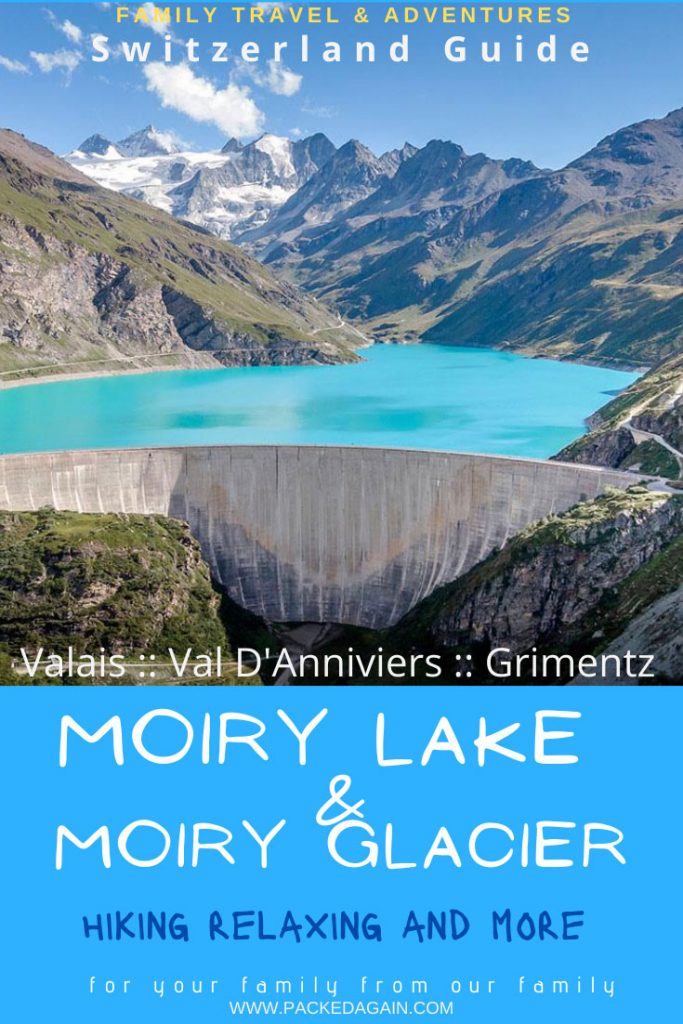
Deep in Val d’Anniviers above the pretty little village of Grimentz you will find the Moiry Valley and the beautiful Swiss Alpine Lake – Lac de Moiry – Lake Moiry.
Known for its beauty, and for many mountaineers and climbers the entry door to some spectacular Alpine Mountain Routes in Valais.
But the beauty of Moiry is its accessibility. Everyone can visit this area, whether it is just for a stroll along the glacial streams, the start for a multi-day hike, a visit to the dam, a family hike at Moiry lake or even a climb up to the Cabane de Moiry. And why not spend the night at the Cabane at 2825 m above sea level right next to Moiry Glacier?
Everyone will find a peaceful place to enjoy Moiry Lake & Moiry Glacier however they wish.
Click on the Video to get a more virtual feel of lake Moiry.

Where is Moiry Lake & Moiry Glacier?
As already mentioned you will find this gem in Valais, Switzerland at the end of Val D’Anniviers above the charming village of Grimentz.
From Sion, the capital of the Canton of Valais, you follow the sign posts to Grimentz. This brings you up a spectacular mountain road passing many beautiful villages. Val d’Anniviers is a valley well worth spending some time as it offers “The authentic Valais” for families and outdoor enthusiasts.
Moiry Lake and the Glacier area are also accessible by public transport (bus). Whether it is from Grimentz village or from Sion train station. Check out the timetable to organise your family Moiry lake hike.

What to Expect when Hiking Moiry Lake & Moiry Glacier
For us this was another bucket list hike we had wanted to do with the kids during the summer 2020. We know the area as we have visited Grimentz and Zinal a few times. Plus we have hiked some of the beautiful trails within Val D’Anniviers such as La Cabane du Petit Mountet in Zinal .
During this family hike we once more realised how truly beautiful the Moiry Valley is.
Expect stunning views all around you. The Moiry Glacier is like a magnet and when standing at the foot of it, the feeling of wanting to discover it further will surely overcome you.

During the hike you must look back and turn around. No matter if you are hiking from the Dam to the Glacier or vice-versa, you will make a lot of stops to marvel at the beautiful nature which surrounds you.
Therefore, make sure you have plenty of time to do the Moiry Lake & Moiry Glacier Hike.
NOTE: the hiking signs by the dam state 4h 45min to make the full upper lake loop. But honestly I think they have mistaken that 🙂 it took us just under 5h to do one side of the lake, and we have meet a couple who had a similar hike time. They were on the upper path as well and it took them a good 4h. Just plan some extra time.


Your options around the Moiry Lake & Moiry Glacier
There are so many hiking options for you at the Moiry area. In this Blog I am showing you the Upper Moiry lake hike starting at the Moiry Glacier.
Upper Hiking trail – Lac de Moiry trail (our choice)
Upper Moiry lake hike starting at Moiry Glacier. Our choice and a more detailed description below in the blog. 7.6 km map distance in 2h 35min, but with all stops it has taken us 5h. I believe 2h 35 is a very fast time estimation. 350m up and 238m down.
If you are planning to hike only one way instead of the round trip I suggest to take the bus first and walk back to your car.
This way, you do not have the worry to catch the bus at the other end. We would have missed our connection as we took our time and enjoyed ourselves.
Full upper Moiry lake loop
Upper Moiry lake full tour. 13.5 km, 4h 45min. Again in my opinion you need to hike very quickly to achieve this time. 568m up and down
Lower Moiry lake trail
Hike the Lower Moiry lake trail. From Moiry Barrage to Moiry Glacier, less strenuous and a shorter 4.4 km. Up 137m down 43m You can also do it in reverse
Full lower lake Moiry loop
Lower Moiry lake full loop trail. 10.8 km, 368 m up and down. The map here says 3h40min. In my opinion this is far too little time.
Hiking to the Cabane de Moiry
Dave and I did this hike pre-kids, we slept at the Cabane as we went climbing the next day up there. A beautiful mountain SAC Cabane right next at the Moiry glacier.
Quite pricey and often fully booked. The hike up is not too long but quite steep. 8.2 km, 642m up. The cabane is at 2826 m altitude.
Enjoy Moiry as a non hiker
Even if you are not hiking around lac de Moiry, take the bus or drive to the Moiry Glacier parking lot.
Two smallish lakes and many other water irrigations from the glacier make this a nice picnic and play area for the whole family. Toilets are by the parking lot and there are even some tables and benches available.
Definitely a fantastic place to spend a relaxing day even with younger kids and it is push chair friendly.

Hiking the upper Moiry Lake Trail (our choice)
Our plan was to do only one side of the Moiry lake, the right side looking at Moiry Glacier. We planned it so that we could take the bus from the Moiry Dam parking lot to Moiry Glacier and start our hike there. This way we were under no time pressure during the hike as our car was waiting at the other end. Check bus time tables here, they are not that frequent, so plan carefully if you do not want to do the full loop trail.
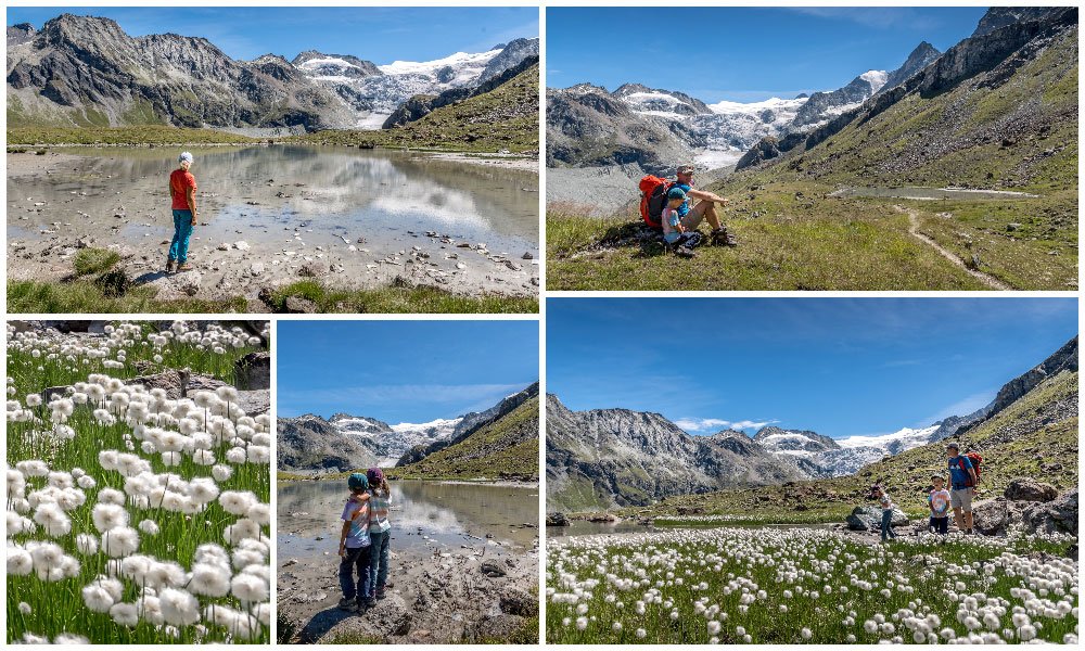
Before we started our hike along the upper Moiry lake we walked around the foot of the Moiry Glacier. It is a beautiful area with 2 smaller lakes and many streams descending from the glacier.

If you feel like it, take an ice-cold foot bath. The kids mentioned that this was the coldest water they have ever felt.
The place is also perfect for your lunch break, and as we were super late starting our hike, this is what we did. We had lunch.
It is easily a place where you can forget time and perhaps even change your mind. Forget you’re actually here to do a hike and instead just relax and marvel at this amazing glacier right in front of you.

Let’s start to Hike along Moiry Lake
From the parking lot (in the middle picture above you can see where the cars are parked ) you cross over the bridge to the water area. It was not very clear at the beginning where the path is but as you start, walk uphill towards the glacier and you will quickly spot the red-white-red markers and soon a yellow sign post.
Remember you are hiking the upper lake trail if you follow this blog post.
The trail guides you up between rocks and a small stream towards the glacier. The path then starts to zigzag up the mountain, until you reach quite some height.
Bit by bit the turquoise water from the lake appears in the distance while the Moiry Glacier behind you gets further away. But take your time and every so often stop and turn around.
I have so many photos as every time it seemed a better shot. 🙂

A nice surprise…
We were climbing up the trail and I was sure we must have nearly reached the highest point when a pretty little lake appeared in front of us on a nice plateau. It was lac de la Bayenna at 2548m.
My husband and I looked at each other and our eyes sparkled as this is a perfect little camping stop. 😉 The kids where happy to play at the lake shore whilst millions of tadpoles sunbathed in the cold water.
I loved in particular the white snowball flowers. It was so pretty and of course a perfect photo opportunity.
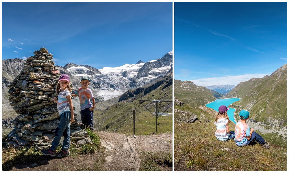
At the highest point of the lac de Moiry Hike
After a nice break by the lake we carried on with our hike. From here you can now see the stone pile standing high on the next hill, which is also the highest point of the hike at about 2550m. Although the sign at the pile says 2500m.
From here you have a stunning view in both directions, the Moiry Lake and the Moiry Glacier. Another great spot to have a little break!
Second Half of the Moiry Lake Hike
From this point, it is downhill all the way to the dam. Right after the stone pile is a section where you probably want to have the young hikers by the hand. The path is narrow, downhill and some slippery rocks are amongst the gravel. There are chains for a bit more security.
The good thing is that this bit is very short and soon you will find yourself back on a more secure hiking trail which guides you to another lake- Lac de Louché. You might see some Herens cows – the local breed – and some pretty little mountain huts. We had the chance to see an alpine milking station, and the cows being milked. The kids loved that.

Getting to the end of our Hike and to the Moiry Barrage
After a good 4.5 h hike with stops, we saw the end of our hike getting closer. The large Barrage of Moiry with its 610 metres long wall, became clearly visible and we started to recognise the curved wall.
It was also nice as now you have both, the beautiful Moiry Glacier and the Moiry Lake in the same vision. And seriously how unreal is the water colour?! We hiked at the end of August, where the water reservoir was pretty full and the glacier water has given the lake an incredible turquoise colour. One must see it to believe it. I can only say that all my photos have no filters on it, the colour is really that strong.

Tips & Suggestions
- The only suggestion I really have is to take the bus first and walk back to your car. This way you do not have any time stress on the hike to be in time for the bus.
- My other suggestion if you hike the upper Moiry lake hike like we did, is to start at Moiry Glacier. It felt less uphill, or maybe say less long. It might have been a bit steeper at the beginning but once we were by Lac de la Bayenna it was a nice relaxing hike back to the barrage.
- There is also a restaurant by the barrage if you wish to treat the family to an ice-cream. 🙂
Alternatives to the Moiry Lake & Moiry Glacier Hike
If your group is more into an adrenaline adventure then there is an amazing Via Ferrata at Moiry. Find out more.
We also saw quite a few families and couples that came up with their E-Bikes or brought the bikes up with the bus and enjoyed a ride down to Grimentz.
Hiking Map for Moiry Lake & Moiry Glacier
How the map works: Click on “Learn More” to get to the full map layout with profile and interactive route indicator.
Hiking Facts
Location:: Moiry, above Grimentz, Val D’Annivier in Valais
Length:: 7.5 km, map says 2h 30, but that is far too quick. We spent a good 4h 30 on the hike.
Level:: easy – hiked with kids age just 5.
Highest point:: 2590 m
Ascent 252m / Descent 345m
Good to know
- Parking is free of charge at Moiry Lake and Moiry Glacier
- There is even a camper van parking lot at Moiry Glacier which allows overnight parking. Check with Grimentz Tourisme for any charges
- Public bus drives to Moiry Glacier
- There are toilets at Moiry Glacier area
- If you wish to bring your push chair, it is possible on the dam wall plus along the road side of the lake. Other than that, drive to Moiry Glacier parking lot and there you have some more options for a little stroll.
- There is a restaurant at Moiry Lake Barrage
Facts about Moiry Lake – Dam
Wikeypedia says: Lac de Moiry is a reservoir in the municipality of Grimentz, in Val D’Anniviers in Switzerland. The lake has a surface area of 1.40 km² and lays at an elevation of 2,249 m. The maximum depth is 120 m. The dam wall is 148 m high, 610 meters long and at the foundation 34 meters wide. It was completed in 1958
Family Hikes & Activities in Valais
- Nendaz – Siviez: Bisse de Chervé – Panoramic Hike in Nendaz
- Arolla – Sentier des Marmottes – Marmot Trail
- Grimentz-Zinal, Hiking up to the Cabane du petit Mountet
- Lac de Salanfe – Hiking up to Salanfe Lake at the foot of Les Dents du Midi
- Lötschental Panoramic Trail – Fafleralp to Lauchernalp with map & video
- Zermatt – Matterhorn Glacier Paradise – An Epic Family Experience
- Zermatt – World’s Highest Glacier Palace – Why you should visit
- Evolène – Ferpècle – Bike ride to the Mont- Mine Glacier, Val D’Hérenes
I hope that the information provided here will prove itself useful when planning the Moiry Lake & Moiry Glacier Hike above Grimentz.
If I have left anything out or you have a question, please ask your questions in the comments below so that other readers can join in the conversation and benefit from your queries also.
Thank you & Never Forget to Travel
If you like it PIN it and tell a friend